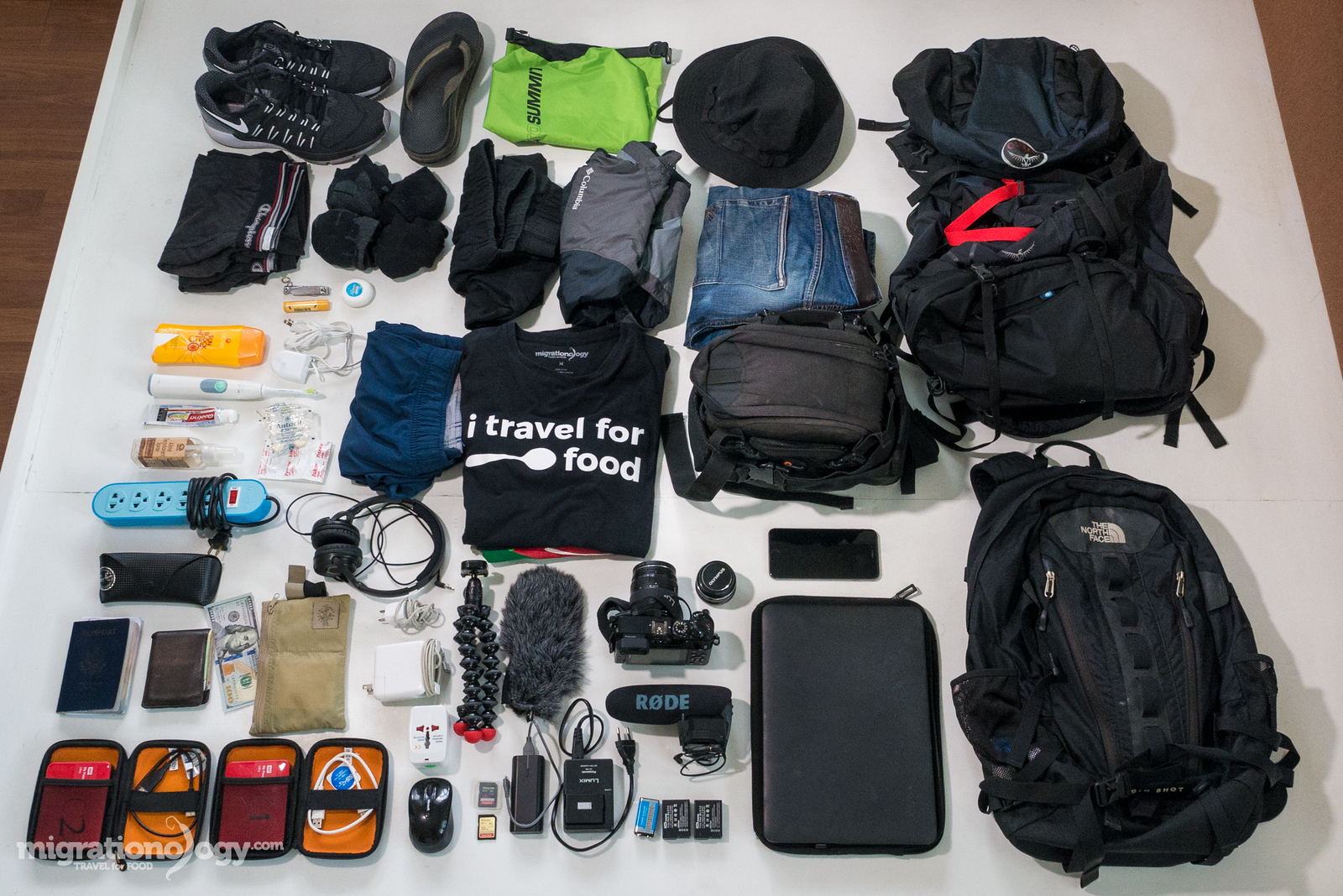
In this blog post I’m going to share with you my exact travel packing list.
And I’m talking, you’re about to get the FULL list of exactly everything I take with me when I travel, and everything I need to run this blog, film and edit food videos on the road.
I hope that by sharing my travel packing list with you, you’ll get some ideas about how you can adapt it to your specific travel needs.
Let’s get started…
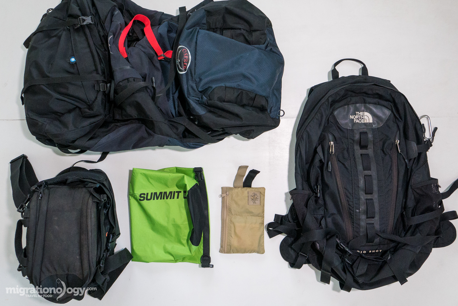
Backpacks / Bags
The bags I use have changed over the years, especially since getting married and also having to carry around more camera equipment and electronics to run my blog and make videos, but here’s my basic setup now:
Get exclusive updates
Enter your email and I’ll send you the best travel food content.
- Osprey Kestrel 68L (main backpack) – This is a much bigger sized backpack that I use to carry stuff for both my wife and I, and we don’t ever even come close to filling it all the way (unless we are switching hotels and have a bunch of bananas and a watermelon, which we sometimes do!). We normally check this bag in on flights as well, because my wife always has some liquids. So just keep in mind that this backpack is much too big for just the stuff I mention on my travel packing list below. But before when I was traveling solo, I used a smaller 28L Osprey pack, and it was perfect.
- North Face Big Shot (computer backpack) – This is a medium sized computer backpack that I carry my computer and all electronics in. It makes a good carry on and I’ve been using it for years.
- Sea To Summit Lightweight Dry Sack 8 Liter (dry bag) – Normally I use this lightweight dry sack to carry all my chargers and some of my electronics in, which then goes into my computer backpack.
- Lowepro Waist Pack (camera bag) – I’m using this particular camera bag right now because I wanted to start using a waist pack to take wear and tear off a single shoulder all day (when I was using a shoulder bag). However, the Lowepro Slingshot, which was my previous camera bag, remains my favorite camera bag (I’m thinking about buying another one, I wore my old one out completely).
- Eagle Creek Hidden Pocket (hidden wallet) – This is one of my favorite travel accessories of all time. I normally put my credit cards, and big amounts of cash (when I have it) in here, and don’t access it frequently.
- Wallet (wallet) – I have a very simple wallet that I always keep in my front pocket, and I keep daily spending money here.
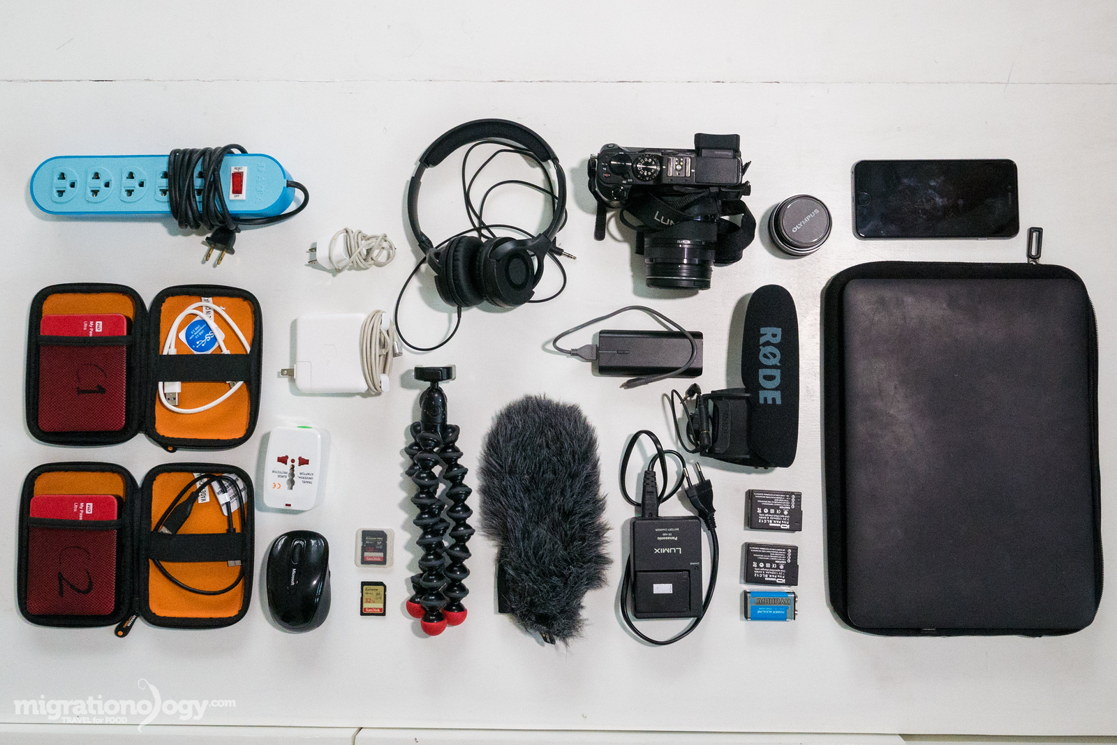
Camera Gear / Electronics
- Panasonic LUMIX GX8 (main camera) – This is the main camera I use for everything you see on this blog.
- Panasonic LUMIX 12 – 35 mm lens (main lens) – This is the main lens I use for videos and photos.
- Olympus 17 mm (extra lens) – This is an extra lens I don’t use very often, but it takes really good sharp photos and is great with lowlight.
- RODE Video Mic Pro (microphone) – Main microphone I use for all my videos.
- RODE dead cat (wind blocker) – I know a dead kitten is a terrible name, but other than being hairy, it has nothing to do with a kitten. Slip this over your mic, and you get good audio in windy conditions.
- Mini plug converter (mini plug adapter) – Unfortunately with my main camera, I need a mini plug adapter to plug in the microphone. It’s a pretty easy thing to do, and I haven’t had any problems using it.
- Generic brand 5 extra LUMIX camera batteries (batteries) – I never want to run out of battery power when filming and traveling.
- 128 GB SD memory card (memory card) – I also have about 5 other random SD cards just in case, but this card usually lasts the entire day of filming and taking photos.
- Joby gorilla pod (tripod) – For space and ease I typically don’t carry a full tripod, but just this small portable hand-held tripod. It’s also good to use as a camera handle when vlogging.
- WD 2 TB external hard drives (2) – I learned the hard way to never backup on just 1 hard drive, when it crashed. Since then, I always buy 2 external hard drives at a time and backup all my content on 2 separate drives everyday, and then immediately delete footage from camera cards.
- MacBook Pro 13.3-Inch (laptop) – For video editing sometimes I wish I had a 15 Inch, but when traveling it’s more convenient to have a 13.3-Inch. I edit all my videos and write all my blog posts on this laptop.
- Speck Case for 13-Inch MacBook (protective laptop case) – I don’t like how this plastic case makes my laptop bigger, but it’s definitely prevented my laptop from lots of scratches – it does its job very well.
- Amazon Basics Computer Sleeve (laptop sleeve case) – Simple laptop sleeve, but I like it because it’s not bigger than it needs to be.
- Microsoft Wireless Mouse (mouse) – This little mouse fits my hand perfectly, and I think it’s the perfect size and weight. Couldn’t edit videos without it.
- Amazon Basics Headphones (headphones) – These headphones are affordable so you don’t need to worry about them, and they sound pretty decent.
- iPhone 6 plus (phone) – This is my current phone that I use to handle all my social media and mobile things.
- TEP mobile wireless (internet device, not pictured) – I bought this mobile wireless internet system and used it mostly traveling in Europe, but it works in many countries around the world. It’s not cheap, but it’s very helpful when you need internet like I do.
- Universal travel plug adapter (universal plug) – This is always good to have so you don’t need to worry about the plug type in any country.
- Power strip (power) – It’s amazing how so many hotels only have a single plug, and I usually need to charge about 5 things at a time, so I just choose to sacrifice and always carry a power strip on my travel packing list.
- Battery bank – You burn through your phone battery pretty fast surfing the internet, so a battery bank is very helpful.
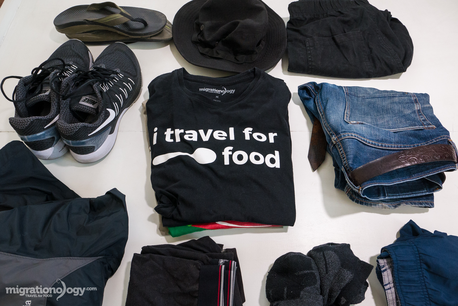
Clothing
For clothing in this travel packing list, you really need to adapt it to your own needs.
These are exactly the clothes I typically travel with, but decide for yourself how many extras of everything you want to carry.
And also, for this clothing section especially it’s just a guide, because you always need to adapt to the climate or place you’ll be going (Ex. if I was traveling somewhere cold I’d need a big jacket).
- Jeans (1) – I wear just one pair of jeans that I buy from my friend Ben who makes custom jeans.
- Lightweight pants (1) – I usually carry a very lightweight pair of pants, for cooler weather or when lounging around and want to avoid mosquito bites.
- Gym shorts or Swimming shorts (1) – I sometimes bring both, or one that doubles as both.
- Walking shorts (1) – Depends on weather, but I also usually bring a pair of walking shorts.
- Belt (1) – I bought a leather belt in Argentina in 2008, and I’ve been using the same belt ever since.
- T-shirts (4) – I normally wear all my own t-shirts, that way I never need to decide what to wear!
- Lightweight rain jacket – This is what I carry with me most of the time traveling in Southeast Asia, but when I travel somewhere really cold, I also have a much warmer Colombia jacket.
- Socks (4) – Right now I’m wearing some Puma socks.
- Underwear (4) – I usually wear Champion, but ExOfficio are pretty good too.
- Walking / running shoes (1) – Right now I have a pair of Nike Air Zoom Odyssey and they are supposed to be really good for your feet. They are pretty comfortable too!
- Light flip flops (1) – Not sure yet if I’ve found the perfect one yet, I’ll link it here when I do. I have a pair of Chaco flip flops, which offer really good foot support, but they are too heavy.
- Goofy sun blocking hat (1) – A cap will also do, but head protection is very necessary sometimes. I have a Colombia floppy hat, and what I like about it is completely squish-able / foldable.
A quick note on laundry: My wife and I never bother with taking the time or effort (or expense) to do laundry when we travel, but instead we wash our clothes in the sink of our hotel or place we’re staying. It’s so much cheaper, faster, and easier, and only takes a few minutes every day.
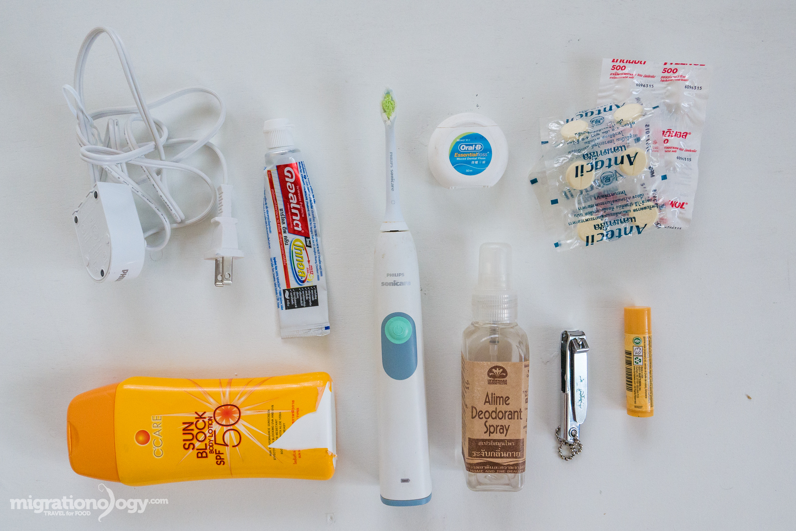
Toiletries
- Electric Toothbrush – My Dad recently persuaded me to buy an electric toothbrush, and I did and haven’t looked back. It’s not light to carry around, but it works well, and I like it.
- Toothpaste – I use whatever toothpaste my wife buys for me.
- Floss (my favorite) – I’m a flosser, if I don’t floss I don’t feel like my teeth are clean.
- Deodorant – I like the idea of natural deodorants these days.
- Sunscreen – It’s a good idea to use sunscreen on a daily basis, especially if you’re traveling outdoors all day.
- Nail clippers – A great thing to always have on your travel packing list.
- Anti acids – Usually keep a few anti acid tablets handy just in case.
- Tylenol – I don’t always carry medications, but sometimes I have a few things like Tylenol.
Note: When it comes to toiletries, just about everything I ever need is available in the country / city I visit, and so I don’t worry too much about other toiletries like shavers, even toothpaste, or other essentials. If I happen to run out, I get a local version wherever I am.
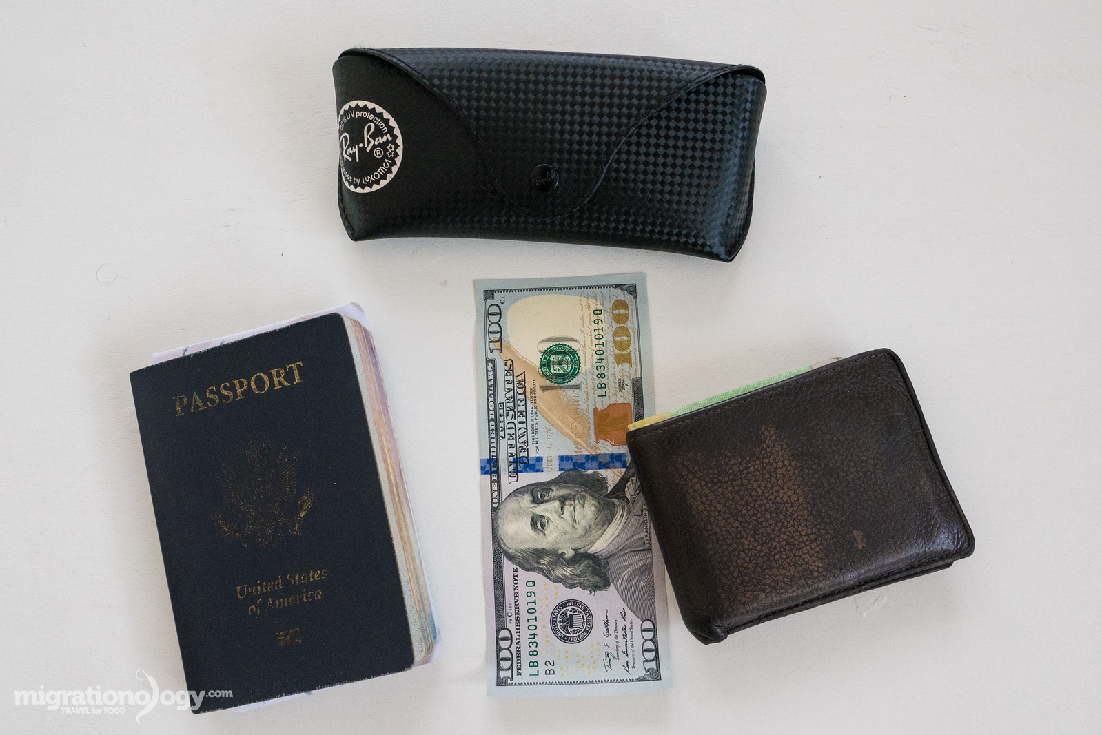
Important Documents and Cards
- Sunglasses – Optional, but well worth it.
- Passport – Make sure you have pages and that you’re passport is still valid for over 6 months.
- Copy of passport – It’s a good idea to make a copy of your passport to carry in a different bag from where your real passport is, just in case.
- ID card – I always carry my driver’s license.
- Credit cards – I mainly use a Chase Sapphire credit card.
- Debit cards – The main debit card and bank I use is Charles Schwab. They will refund your international ATM fees each month.
- $200 cash – This is not exact, but I do like to carry a few hundred dollars in cash just in case of emergency.
Conclusion
I’m not an ultra light minimalist packer, but at the same time I carry a concise amount of things because I know how much more comfortable the travel experience is the lighter your bag.
My general philosophy for any travel packing list is to carry the things you need to be comfortable with and have the tools you need to create what you plan to do, and that’s it.
Hope this travel packing list helps you when you’re packing for your next trip!
Also, check out my Resources Page for more tools and resources I use.
Note: Many of the links on this page are Amazon or other affiliate links, meaning that if you make a purchase, at no extra cost to you, I’ll earn a small commission.
Indonesian Food: 50 of the Best Dishes You Should Eat
Singapore Food Guide: 25 Must-Eat Dishes (& Where to Try Them)
Get exclusive updates
Enter your email and I'll send you the best travel food content.